Maps
Graphical visualisations of rosters are one of the core elements of BuddySpace. Indeed the name 'BuddySpace' itself is derived from the combination of 'Buddy list' and the notion of geographical space. Note that detailed explanations of map construction and editing are provided in the 'BuddySpace Maps How-To' guide.
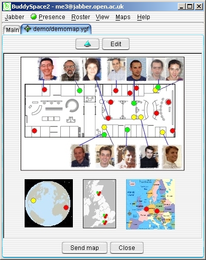
Figure 12. Typical map view (using the Mac Aqua
look and feel), including 4 embedded maps (office layout, world, UK, Europe),
plus
3 'cluster nodes' shown on UK map that each contain a large number of
detailed users available via right-mouse-click..
Figure 12 above illustrates a typical map, which is stored in the folder indicated in the Jabber... Preferences... Mapping tab under 'Local path for maps'. Sub-folders within that named folder will automatically appear in the menu when you click on 'Maps...', and allow you to select different maps to view. Figure 12 reveals several noteworthy features:
- Any graphical image, whether a bitmap (.bmp), JPEG (.jpg) or GIF (.gif) format may be used, including any combinations of these.
- The 'coloured dots' (presence indicators) are live indicators that are superimposed on each image, with locations as indicated in the map-description files you'll find with '.ygf' extensions within the maps folder. The locations are just X, Y coordinate pairs, specified as 'lat(itude)' and 'lon(gitude)' in the aforementioned files, associated with each Jabber ID (JID).
- The world map above is an entirely separate map, simply embedded by specifying its 'offset' (where to put the upper left corner in relation to the overall layout), and 'scale factor' (how big to make it compared to its original full size).
- The UK map shown in the lower middle of Figure 4 depicts three special 'cluster' nodes (around Edinburgh, Oxford, and Southampton, respectively). These each symbolise the existence of numerous 'hidden' users to which you can 'drill down' by right-mouse-click on the '3-dot-cluster' icon. If the cluster icon is all red it indicates that none of the hidden users is online (so no need to drill down). Partially green indicates that at least one hidden user is online, as will be revealed by a right-mouse-click. If two of the three mini-circles is green, it means that more than half of the hidden users are online.
The send map button lets you send an entire map, which includes any maps embedded within it, to anyone on your roster. The edit button lets you add new maps based on any pre-stored image, and add new presence 'dots' and 'cluster dots' directly onto an image using your right-mouse button. A brief study of the sample .ygf files (plain text files) supplied in the maps folder will show how they are structured.
More detailed explanations of map construction and editing are provided in the 'BuddySpace Maps How-To' guide.